


GPS : Introduction : Global Positioning System Surveying
• Global Positioning System Surveying : GPS is a highly accurate navigation system using signals from satellites. To determine a location on the Earth’s surface, irrespective of weather conditions.
• It is dependent on GPS satellites high above the Earth which transmit signals. Signals containing the time and location of the satellite.
• Any ground-based receiver which receives signals from four or more GPS satellites. Can use navigation equations to calculate its location on the Earth’s surface. Constant signaling can then update speed and direction information for moving receivers.
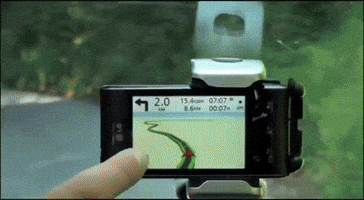
• GPS originally developed for military use but since the 1990s open for civilian use and now used in such common applications as mobile phones, car navigation systems, and of course surveying and mapping.
HOW GPS USED IN SURVEYING?
• Surveying and mapping was one of the first commercial adaptations of GPS. As it provides a latitude and longitude position directly without the need to measure angles and distances between points.
• In practice. GPS technology often incorporated into a Total Station to produce complete survey data.
• GPS receivers used for base line measurements are generally more complex, Expensive than those in common use, requiring a high quality antenna.

METHODS : Global Positioning System Surveying
Static GPS Surveys : Global Positioning System Surveying
• Static GPS survey procedures allow various systematic errors to resolved when high-accuracy positioning required.
• Static procedures used to produce baselines between stationary GPS units by recording data over an extended period of time during which the satellite geometry changes.
Fast-static GPS Surveys : Global Positioning System Surveying
• Fast-static GPS surveys are similar to static GPS surveys. But with shorter observation periods (approximately 5 to 10 minutes).
• Fast-static GPS survey procedures require more advanced equipment. Data reduction techniques than static GPS methods.
• The fast-static GPS method should not used for corridor control. Other surveys requiring horizontal accuracy greater than first order.
Kinematic GPS Surveys : Global Positioning System Surveying
• Kinematic GPS surveys make use of two. Two or more GPS units.
• At least one GPS unit set up over a known (reference) station. Remains stationary, while other (rover) GPS units moved from station to station.
• All baselines produced from the GPS unit. Occupying a reference station to the rover units.
• They can be either continuous “stop and go”. Stop and go station observation periods are of short duration, typically under two minutes.
• Kinematic GPS surveys employed where third-order or lower accuracy standards are applicable.
OPUS Global Positioning System Surveying
• The NGS On-line Positioning User Service (OPUS) allows users to submit individual GPS. Unit data files directly to NGS for automatic processing.
• Each data file submitted processed. With respect to 3 CORS sites.
• OPUS solutions shall not used for producing final coordinates. Elevations on any Caltrans survey.
• OPUS solutions used as a verification. or other procedures.
Equipments : Global Positioning System Surveying
Equipment Post processed GPS surveying equipment generally consists of :
Receiver Requirements
• First-order, second-order, and third-order post processed GPS. Surveys require GPS receivers that are capable of recording data.
• When performing specific types of GPS surveys (i.e. static, fast-static, and kinematic). Receivers and software shall be suitable for the specific survey as specified by the manufacturer.
• Dual frequency receivers shall used for observing. The baselines over 9 miles in length.
• During periods of intense solar activity, dual frequency. Receivers shall used for observing baselines over 6 miles in length
Antennas
• All antennas used for a project. It should be identical.
• For vertical control surveys, identical antennas shall used unless. Software is available to accommodate the use of different antennas.
• For first-order and second-order horizontal surveys, antennas with a ground plane attached shall used. The antennas shall mounted on a tripod or a stable supporting tower.
• When tripods or towers used, optical plummets. Collimators required to ensure accurate centering over marks.
• Fixed height tripods required for third-order. Better vertical surveys.
• The use of range poles and/or stake-out poles to support GPS antennas. Should only employed for third-order horizontal and general-order surveys.

Miscellaneous Equipment Requirements
• All equipment must properly maintained. Regularly checked for accuracy.
• Errors due to poorly maintained equipment. They must eliminated to ensure valid survey results.
• Level vials, optical plummets, and collimators. Shall calibrated at the beginning and end of each GPS survey.
• If the duration of the survey exceeds a week. These calibrations shall repeated weekly for the duration of the survey
Network Design
Baselines
– Baselines developed by processing data collected simultaneously by GPS units at each end of a line.
– For each observation session, there is one less independent (non-trivial) baseline than the number of receivers collecting data simultaneously during the session.
– Magnitude (distance) and direction for dependent baselines obtained by separate processing, but use the same data used to compute the independent baselines. Therefore, the errors correlated.
– Dependent baselines shall not used to compute or adjust the position of stations.
Loops
• A loop defined as a series of at least three independent. Connecting baselines, which start and end at the same station.
• Each loop shall have at least one baseline. In common with another loop.
• Each loop shall contain baselines collected. Its from a minimum of two sessions
Networks
• Each station in a network shall connected. With at least two different independent baselines.
• Avoid connecting stations to a network by multiple. Baselines to only one other network station.
• First-order and second-order GPS control networks. Shall consist of a series of interconnecting closed-loop, geometric figures
Redundancy
• First-order, second-order, and third-order GPS control networks shall designed with sufficient redundancy to detect and isolate blunders and/or systematic errors.
• Redundancy of network design achieved by:
Connecting each network station. With at least two independent baselines
Series of interconnecting – closed loops
Repeat baseline measurement
Reference Stations
• The reference (controlling) stations for a GPS Survey shall meet the following requirements:
Same or higher order of accuracy. As that intended for the project
All on the NAD83 – datum.
All included in, or adjusted to, the California High Precision Geodetic Network (HPGN). With coordinate values that are current and meet reference network accuracy standards
All of the same epoch, or adjusted to the same epoch. Using National Geodetic Survey (NGS) procedures
Evenly spaced throughout the survey project and in a manner that no project station. Its outside the area encompassed by the exterior reference stations
Adjacent Station Rule (20 Percent Rule)
• For first-order and second-order GPS surveys, an independent baseline shall be produced. Between stations that are closer than 20 percent of the total distance between those stations traced along existing or new connections.
• For example, if the distance between Station 5 and Station 1 is less than 20 percent of the distance. Between Station 1 and Station 3 plus the distance between Station 3 and Station 5, an independent baseline should be produced between Station 1 and Station 5.
• If the application of the adjacent station rule is not practical, an explanation shall be included. In the survey notes and/or project report.
• Direct connections shall also made – between adjacent intervisible stations.
Click Here to Visit Our Website


